Mexico City Metrobús
Anuncio
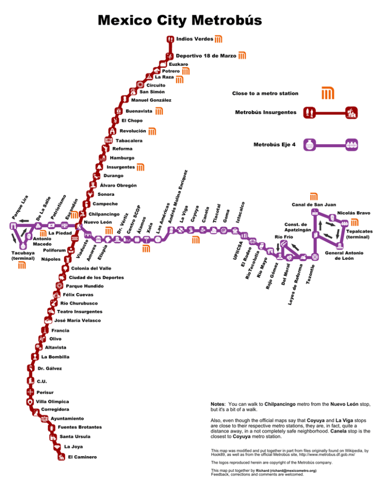
Mexico City Metrobús Indios Verdes Deportivo 18 de Marzo Euzkaro Potrero La Raza Circuito San Simón Close to a metro station Manuel González Buenavista Metrobús Insurgentes El Chopo Revolución Tabacalera Metrobús Eje 4 Reforma Hamburgo o c a lc Izt a a otal Go m T la c Const. de Apatzingán Tepalcates (terminal) o la e ontl Te z orm a al Mor es d e Re f Roj oG ó me z yo Ma R ío R ío Te co lu t de SA IIC Ro El General Antonio de León Del e la Can Am Nicolás Bravo Río Frío UP Xol a s Canal de San Juan Ley Félix Cuevas Río Churubusco oS C OP Ciudad de los Deportes Parque Hundido mo r t iz Colonia del Valle ntr Vé Et io p ía s to ore Am uc ad Vi La Piedad Antonio Macedo Poliforum Tacubaya (terminal) Nápoles Dr. Nuevo León Ce Es Chilpancingo Á la ón nd ca ot tri Pa Campeche Las Sonora o is m lle Sa La De Pa rq ue Li ra Álvaro Obregón é r ic as And rés Mol in a En r La íq u e V ig z a Coy uya Insurgentes Durango Teatro Insurgentes José María Velasco Francia Olivo Altavista La Bombilla Dr. Gálvez C.U. Perisur Villa Olimpica Corregidora Ayuntamiento Fuentes Brotantes Santa Ursula La Joya El Caminero Notes: You can walk to Chilpancingo metro from the Nuevo León stop, but it's a bit of a walk. Also, even though the official maps say that Coyuya and La Viga stops are close to their respective metro stations, they are, in fact, quite a distance away, in a not completely safe neighborhood. Canela stop is the closest to Coyuya metro station. This map was modified and put together in part from files originally found on Wikipedia, by Hook89, as well as from the official Metrobús site, http://www.metrobus.df.gob.mx/ The logos reproduced herein are copyright of the Metrobús company. This map put together by Richard ([email protected]) Feedback, corrections and comments are welcomed.
