Atlas de geoquímica orgánica de Colombia
Anuncio
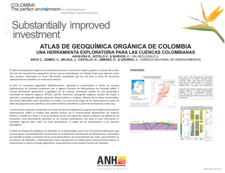
COLOMBIA: The perfect envir nment for Hydrocarbons exploration and production Substantially improved Substantially improved investment investment ATLAS DE GEOQUÍMICA ORGÁNICA DE COLOMBIA UNA HERRAMIENTA EXPLORATORIA PARA LAS CUENCAS COLOMBIANAS AGUILERA R., SOTELO V., & BURGOS, C. - RA GEOLOGIA E.U. ARCE C., GÓMEZ, C., MOJICA, J., CASTILLO, H., JIMÉNEZ, D., & OSORNO, J. - AGENCIA NACIONAL DE HIDROCARBUROS El Atlas de Geoquímica Orgánica de Colombia presenta en una forma simple y gráfica un vistazo del estado del arte del conocimiento geoquímico de las cuencas Colombianas, de utilidad tanto para expertos como para novatos, interesados en tener información actualizada que sea útil para la toma de decisiones exploratorias en Colombia y el norte de Suramérica. Generalities EASTERN CORDILLERA BASIN The source rock geochemical information interpreted for the Eastern Cordillera Basin includes %TOC and Rock-Eval Pyrolysis data from 1512 samples taken in 9 locations; additionally 369 organic petrography samples from 8 locations were interpreted. LOCATION AND BOUNDARIES 76° Caribbean Sea 75° 74° 73° 8° 72° 71° 8° Cucuta VENEZUELA PANAMA VENEZUELA 7° 7° Pacific Ocean COLOMBIA F. S . Crude oil and extracts information from 4 bulk analysis samples, 111 liquid chromatography samples, 114 gas chromatography samples, 125 biomarker sample,42 isotopes and 349 surface geochemistry samples were also interpreted. 6° S. 6° B. El Atlas se encuentra organizado alfabéticamente, siguiendo la nomenclatura y límites de cuencas sedimentarias de Colombia propuestos por la Agencia Nacional de Hidrocarburos de Colombia (ANH). E incluye información geoquímica y geológica de 18 cuencas, incluyendo análisis de roca generadora, contenido de material orgánica (%TOC), pirolisis Rock-Eval, petrografía orgánica, análisis de crudos y extractos, cromatografía líquida y gaseosa, biomarcadores e isótopos. Además de los datos mencionados, dos temas adicionales están presentes en el Atlas, uno acerca del origen de los hidrocarburos a partir de datos de geoquímica de superficie y otro sobre sistemas petrolíferos a partir de correlaciones crudo-roca. S.M. Bucaramanga Tunja . BRAZIL ECUADOR 10 PERU .S .F G Yopal Bogotá 5° 5° 4º Villavicencio BOUNDARIES 4° . North: Igneous and metamorphic rocks from the Santander massif (S.M.) East: frontal thrust system of the Eastern Cordillera 4° .S .F G A. 3° 3° South: Algeciras-Garzón Fault System (A.G.F.S.) West: Bituima and La Salina Fault System (B.S.F.S.) 76° 75° 74° 73° 72° 71° LITHOLOGY-STRATIGRAPHIC UNITS From Barrero et al., 2007 Mesa Fm. León Colorado F. Carbonera Mugrosa F. Concentracion SE La Paz Fm. CUSIANA FAULT ARCABUCO ANTICLINE CHAMEZA FAULT MIDDLEMAGDALENA VALLEY PESCA FAULT NW GUAICARAMO FAULT Esmeraldas F. Picacho Fm. Mirador Fm. Arc. de Socha Los Cuervos Aren. de Socha Lisama F. Barco Fm. Guaduas Fm. Umir Fm. Guadalupe Gp. 0 Middle Miocene - Recent Eocene - Lower Miocene Upper Maastrichtian - Paleocene Coniacian - Lower Maastrichtian Albian - Turonian Berriasian - Aptian Jurassic Chipaque Fm. Simiti Fm. 20 km Tablazo F. The people to speak to EASTERN FOOTHILLS V Real Gp. La Luna F. El Atlas de Geoquímica Orgánica de Colombia se ha desarrollado como una herramienta exploratoria que sirva de apoyo a los profesionales involucrados en la exploración y producción de hidrocarburos, interesados en entender el origen y evolución de las rocas generadoras y las acumulaciones de crudo y gas presentes en las cuencas de Colombia, y adicionalmente como una guía para el trabajo futuro necesario para mejorar el conocimiento y reducir el riesgo exploratorio, especialmente en las cuencas frontera de Colombia. CENTRAL REGION Guayabo F. SALINAS FAULT La información existente y disponible en la base de datos de geoquímica orgánica de la Agencia Nacional de Hidrocarburos (ANH) se empleó para generar gráficas de la caracterización deposicional, de madurez térmica y calidad de crudos y rocas generadoras, junto con mapas de calidad y madurez de algunas de las principales rocas generadoras presentes en las cuencas Colombianas. Con base en esta información se presentan algunas ideas sobre las rocas generadoras, el origen de los hidrocarburos y los sistemas petrolíferos. WESTERN FOOTHILLS Paja Fm. Basement Une Fm. Fomeque Fm. Ermitaño Fm. Rosablanca Fm. Modified from Cooper et al., 1995 Une Fm. Aren. de Las Juntas Lutitas de Macanal Los Santos Fm. Girón Fm. Mainly conglomerates Mainly Sandstones Girón Fm. Shales Limestones V: Volcanoclastics From Barrero et al., 2007 www.anh.gov.co COLOMBIA: The perfect envir nment for Hydrocarbons exploration and production Substantially improved Substantially improved investment investment ATLAS DE GEOQUÍMICA ORGÁNICA DE COLOMBIA UNA HERRAMIENTA EXPLORATORIA PARA LAS CUENCAS COLOMBIANAS Source Rock Characterization Crude Oil Quality 3 LEGEND A E 20 25 30 35 40 45 50 55 60 M at ur ity 1 600 600 A B 2000 4000 6000 IF 8000 10000 12000 M ID DL 15 Biodegraded Oil Depth (Feet) AG M 1200000 Oilseeps are located widespread all over the basin MASS DA LE NA NDER BA 1250000 2 % Sulfur N 50Kms SI 25 SANTA 0 10 Hydrogen Index (mg HC / gTOC) 1300000 The number of wells and/or surface locations with geochemical information in the Eastern Cordillera Basin is 12 . 5 LEGEND 0 BARCO Fm. BARCO- LOS CUERVOS Fm. CARBONERA Fm. GACHETA Fm. GUADALUPE Fm. MIRADOR Fm. UNE Fm. UNKNOWN VENEZUELA BUCARAMANGA 0 API Gravity 500 Excellent Generation Potential Low thermal maturity 400 300 200 14000 100 1150000 Poor Generation Potential and/or High thermal maturity CORRALES-1 16000 BOLIVAR-1 (BOLÍVAR FIELD) TAMAUKA-1 CORMICHOQUE-1 Heavy Oil 0 10 20 30 40 Condensates 0 0 50 10 Immature 1050000 N SI O S BA NA B VILLARRICA-1 Wells with geochemical information ALPUJARRA-1 Oil seeps % Sulfur LL AN ALE AGD 2 UPP ER M VILLAVICENCIO APICALA-1 Lacustrine or Continental 800000 Cities/Towns 900000 950000 1000000 1050000 1100000 1150000 C 1.35% Ro 200 III 1 390 410 430 450 2 470 490 510 530 1.1% Ro 1200000 8 18 0.5% Ro 1000000 26 4 -The oils with Oleanane/C30 Hopane > 0.2 are found in Upper Cretaceous (Guadalupe Fm.) and Tertiary reservoirs (Mirador and Carbonera formations), which are interbedded or in close proximity to Tertiary shale sequences deposited in transitional marine environments, which might have high terrestrial organic matter input, causing the increase of Oleanane/C30 Hopane ratios in these oils (Figure B). s rre e T 10 1 Bi 25 eg d o r at ad a tri e yp T l III n ge o r Ke 100 150 200 250 300 Oxygen Index (mg CO2 / gTOC) II Marine Deltaic (CENOZOIC) III en n m ge n ro viro Ke e d n K II g E ixe M pe cin Ty du e ,R l ga Al en g ro 0.8 t ing 12 6 22 - This indicates that the Gachetá Formation could be the main source for the accumulations found in the basin. However the presence of oils with Oleanane/C30 Hopane > 0.2 is indicative of an alternate source in the basin of Tertiary age and/or with an important terrestrial organic matter input (Figure B). uc 20 15. LA MARÍA-1 16. LETICIA-1 17. POMARROSO-1 18. PORE-1 19. QUENANE-1 20. RANCHO HERMOSO-1 21. RÍO ELE-1 22. SAN JOAQUÍN-1 23. SANTIAGO-1 24. SANTIAGO-2 25. SIMÓN-1 26. SURIMENA-1 27. YALÍ-1 d Re 13 23 24 50 B g xin idi Ox 1. ANACONDA-1 2. APIAY-4P 3. ARAUQUITA-1 4. ARIMENA-1 5. BUENOS AIRES X-14 6. CAÑO DUYA-1 7. CAÑO VERDE-1 8. CASANARE-1 9. CASTILLA-1 10. CHAPARRAL-1 11. CHIGUIRO-1 12. ENTRERRIOS-1 13. GOLCONDA A-1 14. LA HELIERA-1 11 0.1% Ro 0 A - There are very few extract samples in the basin to provide strong correlations with the oils found in the basin, but the few extracts from the Gachetá Formation show some correlation with crude oils from the Une, Guadalupe, Mirador and Carbonera reservoirs (Figure A). Oleanane / C30Hopane 21 15 16 IV 0 1 Pristane / nC17 LEGEND 3 0.3% Ro III 100 550 100 1100000 200 Petroleum Systems (Crude-Rock Correlations) Gacheta Formation 0.7% Ro 300 Tmax (oC) Ni / V 0.9% Ro 400 - The Tmax maturity parameter vs Hydrogen Index graph shows that many samples from the Cretaceous to Cenozoic units mentioned, have reached early maturity to overmature conditions in the basin. Being the samples from the Cretaceous Fomeque, Chipaque and Hiló formations the more mature in the basin (Figure C). 370 0 500 - The Oxygen Index vs Hydrogen Index diagram (Van Krevelen diagram) shows that rock samples from the Cretaceous Caballos, Conejo, La Luna, Villeta and Umir formations have type II oil-prone kerogen. There are also samples from these formations with type III gas-prone characteristics. In the case of the Cenozoic units (Guaduas, Concentración and Bogotá formations) their samples are indicative of type III gas-prone kerogen to type IV kerogen. (Figure B). 0 1200000 II - The data obtained from pyrolysis Rock-Eval of rock samples for Hydrogen Index (HI) and S2 peak, indicate that samples from the Cretaceous Caballos, Conejo, La Luna, Villeta, Guadalupe, Los Pinos and Umir formations and the Cenozoic Arcillas de Socha Formation have good generation potential (HI > 200mg HC/g TOC and S2 > 5 mg HC/g rock). It is important to consider that these and other units with source rock characteristics, are or were deeply buried in the basin by thrusting, and the poor generation values obtained from many samples could reflect the depletion effect caused by the high thermal maturity reached by these rocks in sub-thrust sheets (Figure A). 400 0 B I I - The sulfur content of most crude oils is lower than 1%, and its Ni/V ratio below 1, suggesting that they are produced from rocks deposited in a marine suboxic environment with some terrigenous organic matter input (Figure C). Undetermined seeps Map datum: Magna Sirgas Coord. origin: Bogotá Overmature 600 - There is no direct relationship between depth and crude oil quality, indicating that similar quality oils can be found at different stratigraphic levels, probably related to vertical migration along faults. But additionally there is the fact that different API gravity oils can be found at similar depths, reflecting different preservation (biodegradation) and/or thermal maturities (Figure B). 1 Gas seeps 850000 40 0.5% Ro ASIN Anoxic Marine BOGOTÁ - Normal and light oils with API gravities ranging from 10° to 50° and sulfur content between 0 and 2.5% are present in the basin. There is no straight relationship between sulfur and API gravity, but oils above 25° API have sulfur values below 1%, and oils below 25° show sulfur content with values up to 3%. This suggests that in the basin there are oils with different thermal maturities and/or different degrees of preservation (biodegradation, water washing, etc.), because crudes having similar API gravities have different sulfur contents, which might indicate that biodegradation is increasing sulfur content and/or reducing API gravity, or different source rocks, considering that oils sourced from shales usually have lower sulfur content than oils from carbonates (Figure A). C Hydrogen Index (mg HC / gTOC) CHITASUGA-1 900000 Mature II 1000000 30 20000 3 950000 20 S2 (mg HC / gROCK) API Gravity YOPAL SUESCA NORTE-1 Light Oil 18000 0 TUNJA 1100000 Normal Oil BOGOTA Fm. CABALLOS Fm. CABALLOS-UNE Fm. CACHO Fm. CACHO_GUADUAS Fm. CALIZAS DE TETUÁN Fm. CHIPAQUE Fm. CHURUVITA Fm. CONCENTRACION Fm. CONEJO Fm. El DIAMANTE Fm. HILO Fm. LA NAVETA Fm. SOCOTA Fm. TRINCHERAS Fm. FOMEQUE Fm. NEVADA Gr. GUADALUPE Fm. GUADUAS Fm. LA FRONTERA Fm. LA LUNA Fm. LOS PINOS Fm. MONSERRATE Fm. PICACHO Fm. PINZAIMA Fm. PLAENERS Fm. SOCOTA SHALE Fm. TIBASOSA Fm. TILATA Fm. UNE Fm. UNKNOWN VILLETA Fm. YAVÍ Fm. A. TIERNA Fm. Arc. DE SOCHA Fm. LIDITA SUPERIOR Fm. UMIR Fm. Hydrogen Index (mg HC / gTOC) Wells and Seeps n io it ur at M y 0.6 0.4 0.2 Shelf Marine Marine Deltaic (CRETACEOUS) 2 9 0.1 900000 0 0.1 1 10 0 100 1 2 3 4 5 Pristane / Phytane Phytane / nC18 LEGEND CRUDE- CARBONERA Fm. CRUDE- GACHETA Fm. CRUDE- GUADALUPE Fm. CRUDE- MIRADOR Fm. CRUDE- UNE Fm. ROCK- BARCO Fm. ROCK- CARBONERA Fm. ROCK- CHIPAQUE Fm. ROCK- GACHETA Fm. ROCK- GUADALUPE Fm. ROCK- MACARENA Fm. ROCK- MIRADOR Fm. 800000 Vitrinite reflectance (%Ro) 1000000 1100000 1200000 1300000 1400000 1500000 1600000 1700000 The people to speak to www.anh.gov.co
