mapa preliminar de zonas de amenazas por inundaciones del
Anuncio
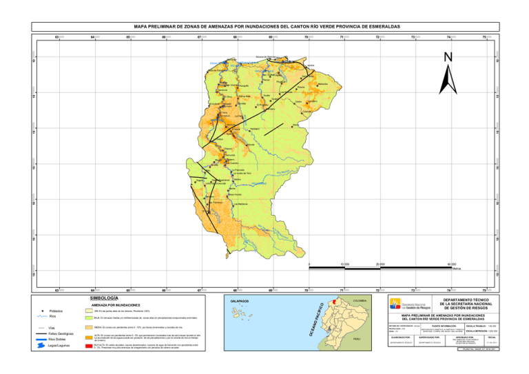
MAPA PRELIMINAR DE ZONAS DE AMENAZAS POR INUNDACIONES DEL CANTON RÍO VERDE PROVINCIA DE ESMERALDAS 670000 680000 690000 RÍO LAGARTO ESTERO TAPAILA RÍO MATE Boca de Cabuyal 10 110000 arto Piquigual Chontillal Guajalí Cacho El Progreso 740000 750000 ± Las Delicias Partidero Lavadero Culebrita M e Rí o a t La Perla RÍO VERDE 10 100000 Gualte Palma Real El Olivo Bellavista Pizares Sandoval La Torre Chontaduro 730000 Santa Rosa ag Palmar El Llano San Vicente Chunguillo Zapallo El Porvenir 720000 Vainilla oL Rí RÍO OSTIONES San Vicente Lagarto El Achiote 710000 Bocana de Ostiones África Río Verde Estero Chamero 700000 10 120000 660000 10 110000 650000 Chemere Venado o Rí C Sirena Partidero El Moral 10 100000 640000 10 120000 630000 La Sierpe ho nt ur ad o Mocole Chazara Chumundé Venado Tulpero Las Guantas La Pascuala La Vuelta del Toro Brito Dogola 10 090000 10 090000 Playón Nueva Esperanza Unión de Chumundé Meribe Río Mer ib e RÍO MERIBE Estero Hondo Partidero San Francisco 10 080000 10 080000 Nache Las Medianas Rí de R ío M Pop Rí er ra c a R ío 10 070000 un dé Río V bo a oP a um 10 070000 um El Ceibo o C h i lla mb Poblados Ríos Vías Fallas Geológicas Ríos Dobles Lagos/Lagunas AMENAZA POR INUNDACIONES SIN: En las partes altas de los relieves. Pendiente >25% BAJA: En terrazas medias y/o indiferenciadas de zonas altas en precipitaciones exepcionales anormales MEDIA: En zonas con pendientes entre 0 - 12% por lluvias torrenciales y crecidas de ríos ALTA: En zonas con pendientes entre 0 - 5% que permanecen inundadas mas de seis meses durante el año. La acumulación de las aguas puede ser producto de las precipitaciones y por la crecida de rios en tiempo de invierno. MUY ALTA: En valles aluviales, cauces abandonados, cuerpos de agua de transición con pendientes entre 0 - 2%. Presentan muy alta amenaza de anegamiento con periodos de retorno anuales 690000 700000 710000 720000 GALAPAGOS 730000 740000 750000 DEPARTAMENTO TÉCNICO DE LA SECRETARÍA NACIONAL DE GESTIÓN DE RIESGOS COLOMBIA O SIMBOLOGÍA 680000 ÍFI C 670000 40.000 Metros MAPA PRELIMINAR DE AMENAZAS POR INUNDACIONES DEL CANTON RÍO VERDE PROVINCIA DE ESMERALDAS OP AC 660000 AN 650000 20.000 OC E 640000 10.000 10 060000 10 060000 l 630000 0 SIST EMA DE C OORD ENAD AS: WGS84 PR OYEC CIÓN: UTM ZONA: 17S PERU FUENTE INFORMACIÓN: CARTOGRAFÍA PLANIMÉTICA, ALTIMÉT RICA Y TEMÁTICA: SENPLADES, CLIRSEN, IGM, MAGAP, MAE, INIGEMM ELABO RADO POR: SUPERVISADO POR: DEPAR TAMEN TO TÉCN ICO DEPAR TAMEN TO TÉCN ICO ESCALA TRABAJO: 1:50.000 ESCALA IMPRESIÓN: 1:250.000 APROBADO POR: DRA. MARÍA DEL PILAR CORNEJO SECRET ARIA NACIONAL DE GESTIÓN DE RIESGOS FECHA: 31 / 05 / 2011 PLANO No. SNGR_DT_M.M_001
