Case study: Tanzania - Drones in Humanitarian Action
Anuncio
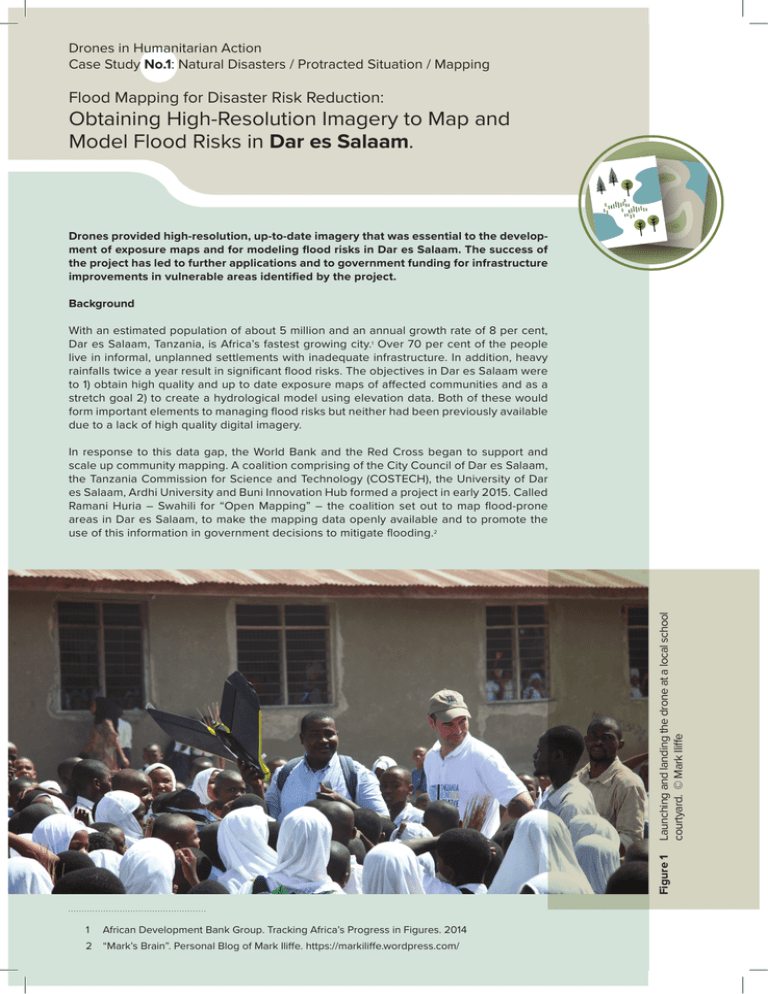
Drones in Humanitarian Action Case Study No.1: Natural Disasters / Protracted Situation / Mapping Flood Mapping for Disaster Risk Reduction: Obtaining High-Resolution Imagery to Map and Model Flood Risks in Dar es Salaam. Drones provided high-resolution, up-to-date imagery that was essential to the development of exposure maps and for modeling flood risks in Dar es Salaam. The success of the project has led to further applications and to government funding for infrastructure improvements in vulnerable areas identified by the project. Background With an estimated population of about 5 million and an annual growth rate of 8 per cent, Dar es Salaam, Tanzania, is Africa’s fastest growing city.1 Over 70 per cent of the people live in informal, unplanned settlements with inadequate infrastructure. In addition, heavy rainfalls twice a year result in significant flood risks. The objectives in Dar es Salaam were to 1) obtain high quality and up to date exposure maps of affected communities and as a stretch goal 2) to create a hydrological model using elevation data. Both of these would form important elements to managing flood risks but neither had been previously available due to a lack of high quality digital imagery. Figure 1 Launching and landing the drone at a local school courtyard. © Mark Iliffe In response to this data gap, the World Bank and the Red Cross began to support and scale up community mapping. A coalition comprising of the City Council of Dar es Salaam, the Tanzania Commission for Science and Technology (COSTECH), the University of Dar es Salaam, Ardhi University and Buni Innovation Hub formed a project in early 2015. Called Ramani Huria – Swahili for “Open Mapping” – the coalition set out to map flood-prone areas in Dar es Salaam, to make the mapping data openly available and to promote the use of this information in government decisions to mitigate flooding.2 1 African Development Bank Group. Tracking Africa’s Progress in Figures. 2014 2 “Mark’s Brain”. Personal Blog of Mark Iliffe. https://markiliffe.wordpress.com/ In February 2015, the World Bank involved Drone Adventures, a non-profit organization based in Switzerland, to test the idea of collecting and using drone imagery for this mapping exercise. Drones were not initially foreseen as a data collection tool within this project, perhaps also because there is little precedent for the use of this method but the opportunity to obtain reliable, high-quality imagery at a relatively good price was seen as chance to explore innovative technologies. “Focusing the project as a research- in-action demonstration makes it a bit easier. We shouldn’t over promise, but if we can put it out there in an open format, we enable researchers to see what it is capable of doing.”3 – Edward Anderson, World Bank During the second phase the majority of the data was obtained, including 20 000 optical images covering an area of 88 km2 with an average resolution of about 5 cm.4 In order to achieve this kind of coverage, 2-3 eBee drones were flying simultaneously operated by one pilot. Drone Adventures used eBee Image processing software, Postflight Terra 3D to patch the separate images together to create two main datasets: an optical 2D orthomosaic model and a 3D surface model. The processing was done in Switzerland over a period of 6 weeks with high-memory speed processors that produced a total of 700 GB of data. The dataset was so large that it had to be mailed physically on a hard drive to the Tanzania World Bank office. Implementation The data collection was done in two phases both times using an eBee fully automated mapping drone manufactured by Sensefly. In the first phase, Drone Adventures mapped a section of several kilometers of the highway, the river and part of the Tamale neighborhood. The methods and results were shared with local government officials and city planners, who then provided input for priority areas for the second mapping phase. Figure 2 Extract orthomosaic. 3 Edward Anderson. World Bank. Interview from 13 November 2015. 4 David Rovira, Drone Adventures. Interview from 28 October 2015. Data use and Information Products COSTEC has made the data available to the public and has published raw images on OpenAerialMap, a collection of openly licensed aerial imagery. Several information products have already emerged. Maps as decision-making tools Upon obtaining the 2D orthomosaic imagery, The Humanitarian OpenStreetMap Team (HOT) organized local volunteers to first determine the respective communities’ mapping priorities and to then digitize roof prints, roads, drains, and trees and to mark businesses and roads. Through this exercise the aerial imagery was converted into digital street maps.5 With this information houses, businesses, and critical infrastructure have been mapped with unprecedented accuracy. Figures 3 and 4 were available maps of the same area before and after the drone imaging. Figure 5 shows a detailed map of the districts drainage system that was made in the community mapping initiative. 5 Humanitarian OpenStreetMap http://tasks.hotosm.org/ project/1120 Figure 3 Google maps snapshot shows little information on what are actually densely populated areas of Dar es Salaam. Retrieved on 3 December 2015. Figure 4 Level of detail available on OpenStreetMap shows the details of houses and roads. Retrieved on 3 December 2015. Source: http://www.openstreetmap.org/ Figure 5 Detailed drainage map that was drawn up with help of the orthomosaics. Hydrological model The second main outputs are based on 3D surface models. Using software called LAStools, the buildings and other artificial structures could be removed to create a model of the underlying terrain. Follow-up work to obtain a model that can help with creating a city-wide flood risk profile is currently in progress. The need to come up with a hydrological model is also where limitations of the technology are surfacing. In order to account for flash floods, one would have to map the entire watershed of around 800km2, not just the significantly smaller exposed urban area for which imagery has been obtained. The processing needs using these drones are quite heavy and mapping a whole watershed of this size would present a truly extraordinary effort. “We are trying to learn what is good enough and what is a significant improvement to the status quo. We may find out that it would take way too long to map 800km2 watershed with a resolution of 3cm”. 6 6 Edward Anderson. World Bank. Interview from 13 November 2015. Figure 6 Using ground points, LAStools can develop a digital terrain model (DTM) from the digital surface model (DSM) removing the buildings, which is currently used to work out the hydrological model. Source: Rapidlasso.com Evaluation Impact Community engagement It is too early to understand the full impact that having this kind of high quality imagery will have on decision-making and flood risk mitigation. However a few clear uses and advantages have already emerged. Local authorities and communities were involved throughout the planning, data collection and data use phases. In particular, COSTECH, the technology branch of the Ministry of Communication, Science and Technology, helped decide which districts needed to be mapped, and Ministry officials were present every day of the drone flights. As a result of the transfer of knowledge and the Ministry’s acquisition of two drones, COSTECH now has the capacity to conduct drone flights and to process flight data. The Tandale Ward Office and the Department of Urban Planning of the Kinondoni Municipal Council are now using the maps for urban planning purposes. Local authorities see the maps as starting points in the evaluation of areas subject to improvements, and for the response to flooding and related disease outbreaks. The detailed ward maps allow public health officials to identify specific houses with known cholera patients in case of an outbreak allowing for much more efficient response through targeted dispatch of medical care. The exposure maps that include up-to-date buildings and infrastructure now enable planners to identify places that get flooded and to pinpoint where drainage systems need to be installed.7 This new capacity has even helped the city council acquire funding from the central government to install drainage systems in vulnerable places. According to Mark Iliffe from the World Bank, “creating a flood inundation model is the holy grail but we have not been able to achieve this yet”8. However, the work is still in progress. Deterministic flood models have been created with the drone images that can help understand potential inundating zones. Choice of method “You can far more reliably launch a drone and get imagery compared to a satellite or plane because you can fly underneath the cloud cover”. –Edward Anderson In the case of modeling flood risk and obtaining exposure maps for Dar es Salaam, having high resolution and up-todate imagery was seen by a variety of involved actors as highly valuable. Conventional methods that rely on qualitative data and satellite imagery with a resolution of 30 cm were available to complete this mapping,9 but were severely limited. The city is growing and changing at such a rate that satellite imagery often becomes outdated within a year. Aerial images obtained with airplanes were often limited due to cloud cover. 7 Osiligi Lossai Tandale Ward Executive Officer and Juliana Letara Head of Urban Planning Kinondoni Municipal Council. Interviewed by Mark Iliffe. 21 October 2015. 8 Mark Iliffe. World Bank. Interview from 19 October 2015. 9 Mark Iliffe. World Bank. Interview from 19 October 2015. Social acceptance Often little is known about community social acceptance on the use of drones for humanitarian or development purposes. However, in Dar es Salaam FHI 360 interviewed 14 high-level government officials and 208 community members who witnessed drone flights over the city. The study found that both “community witnesses and government officials were positive about the potential of [drone] technology in Tanzania”.10 Among many other potential uses, both community members and government officials noted disaster relief and the transport of medical supplies as promising applications. General concerns included the potential for accidents and for threats to national security. In addition, some of the latrines in the mapped communities do not have covers, raising concerns related to visual privacy among community members. Plans for adaptation Both the Tanzanian government and the World Bank plan on continuing the use of drones for mapping purposes. The government is seeing the maps as a baseline to understand how the city is developing and changing following improvements to infrastructure and COSTEC has now developed the capacity to do follow-up mapping on their own. On the strength of the success of the initial mapping, the Tanzanian government is planning to complete mapping of the remaining areas in Dar es Salaam, as well as creating annual maps for change detection. The World Bank also intends to continue to use drones, however some concerns regarding the future regulatory environment have been expressed. This effort was only possible because of the close collaboration with the Tanzanian government and because there are no limiting regulations on the use of drones in place. 10 Eichleay, M. et al, Using Unmanned Aerial Vehicles for Development: Perspectives from Citizens and Government Ministry Employees in Tanzania. FHI 360. Unpublished. 2015. Resources Open Aerial Map - Repository of aerial imagery that was collected with the drones: http://beta.openaerialmap.org/#/-6.795517204616081,39.2431640625,10/-6.795517204616062,39.2431640625 Open Street Map – The detailed city map of Dar es Salaam. http://www.openstreetmap.org/#map=16/-6.7918/39.2398 Ramani Huria – Mapping Initiative in Dar es Salaam http://ramanihuria.org/ The views expressed herein should not be taken, in any way, to reflect the official opinion of the European Union, and the European Commission is not responsible for any use that may be made of the information it contains. Technical Specifications & Credits Type of system: eBee Fixed Wing Mapping Microdrone Deploying Agency: World Bank and Humanitarian OpenStreetMap Team Piloting Agency: Drone Adventures Dates of Deployment: February and March 2015 Author: Denise Soesilo With special thanks to: Joel Kaiser (Medair), Audrey Lessard-Fontaine (CartONG), Martin Noblecourt (CartONG), Paul Uithol (HOTOSM), Mark IIiffe (World Bank), Otto Simonett (Zoi Environment Network) for their inputs and comments. Swiss Foundation for Mine Action (FSD) 7bis, Avenue de la Paix - Floor 2 CH-1202 Geneva Switzerland drones.fsd.ch
