Cartographie de la région du Bas-Saint
Anuncio
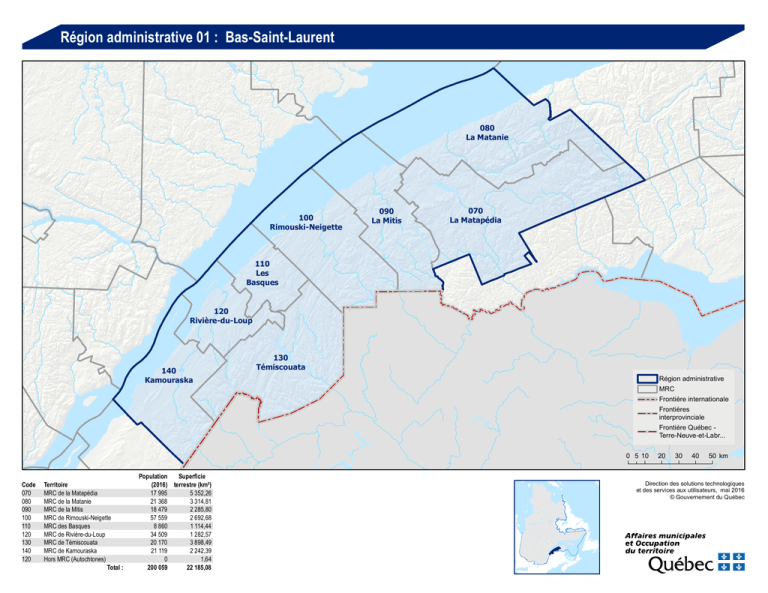
Région administrative 01 : Bas-Saint-Laurent 080 La Matanie 100 Rimouski-Neigette 090 La Mitis 070 La Matapédia 110 Les Basques 120 Rivière-du-Loup 140 Kamouraska 130 Témiscouata Région administrative MRC Frontière internationale Frontières interprovinciale Frontière Québec Terre-Neuve-et-Labr... 0 5 10 Code 070 080 090 100 110 120 130 140 120 Territoire MRC de la Matapédia MRC de la Matanie MRC de la Mitis MRC de Rimouski-Neigette MRC des Basques MRC de Rivière-du-Loup MRC de Témiscouata MRC de Kamouraska Hors MRC (Autochtones) Total : Population Superficie (2016) terrestre (km²) 17 995 5 352,26 21 368 3 314,81 18 479 2 285,80 57 559 2 692,68 8 860 1 114,44 34 509 1 282,57 20 170 3 898,49 21 119 2 242,39 0 1,64 200 059 22 185,08 20 30 40 50 km Direction des solutions technologiques et des services aux utilisateurs, mai 2016 © Gouvernement du Québec MRC de la Matapédia Code 07005 07010 07018 07025 07030 07035 07040 07047 07057 07065 07070 07075 07080 07085 07090 Désignation M M V M P P P V M P P M M M P Municipalité Sainte-Marguerite-Marie Sainte-Florence Causapscal Albertville Saint-Léon-le-Grand Saint-Zénon-du-Lac-Humqui Sainte-Irène Amqui Lac-au-Saumon Saint-Alexandre-des-Lacs Saint-Tharcisius Saint-Vianney Val-Brillant Sayabec Saint-Cléophas SaintDamase, P SaintNoël, VL SaintMoïse, P LacAlfred, NO Population Superficie (2016) terrestre (km²) 189 86,54 394 102,93 2 315 161,16 241 103,47 939 128,52 358 112,80 353 134,54 6 146 122,38 1 396 80,68 279 89,84 425 79,06 480 145,43 946 77,90 1 788 131,21 331 97,84 SaintVianney, M Sayabec, M SaintCléophas, P 070 LacMatapédia, NO ValBrillant, M SainteIrène, P Total : Amqui, V SaintAlexandredes-Lacs, P 0 - 1999 h. 2 000 h. - 9 999 h. 10 000 h. - 49 999 h. 50 000 h. - 99 999 h. 100 000 h. - 2 000 000 h. 17 995 5 352,25 30 40 km LacCasault, NO Albertville, M SainteFlorence, M SainteMargueriteMarie, M Routhierville, NO 0 Population (décret 2016) Population Superficie (2016) terrestre (km²) 551 110,25 429 44,48 410 116,19 15 627,50 0 274,19 0 15,59 5 1 425,37 0 937,08 0 76,99 5 70,31 SaintTharcisius, P RivièreVaseuse, NO RivièrePatapédiaEst, NO Désignation P VL P NO NO NO NO NO NO NO Municipalité Saint-Moïse Saint-Noël Saint-Damase Routhierville Rivière-Vaseuse Rivière-Patapédia-Est Lac-Casault Ruisseau-des-Mineurs Lac-Alfred Lac-Matapédia RuisseaudesMineurs, NO Lac-auSaint-LéonSaumon, M Causapscal, V le-Grand, P Saint-Zénondu-LacHumqui, P Code 07095 07100 07105 07902 07904 07906 07908 07910 07912 07914 5 10 20 Direction des solutions technologiques et des services aux utilisateurs, mai 2016 © Gouvernement du Québec MRC de la Matanie Code 08005 08010 08015 08023 08030 08035 08040 08053 08065 08073 08080 08902 Municipalité Les Méchins Saint-Jean-de-Cherbourg Grosses-Roches Sainte-Félicité Saint-Adelme Saint-René-de-Matane Sainte-Paule Matane Saint-Léandre Saint-Ulric Baie-des-Sables Rivière-Bonjour Désignation M P M M P M M V P M M NO Total : 080 Population Superficie (2016) terrestre (km²) 1 074 441,22 181 113,76 379 63,65 1 110 91,38 480 101,62 1 076 255,70 220 84,22 14 206 195,65 416 104,26 1 597 120,20 629 65,03 0 1 678,12 21 368 3 314,81 SainteFélicité, M SaintUlric, M Baie-desSables, M Matane, V SaintLéandre, P SaintAdelme, P SaintRené-deMatane, M GrossesRoches, M Les Méchins, M Saint-Jean-deCherbourg, P RivièreBonjour, NO SaintePaule, M 0 Population (décret 2016) 0 - 1999 h. 2 000 h. - 9 999 h. 10 000 h. - 49 999 h. 50 000 h. - 99 999 h. 100 000 h. - 2 000 000 h. 5 10 20 30 40 km Direction des solutions technologiques et des services aux utilisateurs, mai 2016 © Gouvernement du Québec MRC de la Mitis Code 09005 09010 09015 09020 09025 09030 09035 09040 09048 09055 09060 09065 09070 09077 09085 Municipalité La Rédemption Saint-Charles-Garnier Les Hauteurs Sainte-Jeanne-d'Arc Saint-Gabriel-de-Rimouski Saint-Donat Sainte-Angèle-de-Mérici Padoue Métis-sur-Mer Saint-Octave-de-Métis Grand-Métis Price Saint-Joseph-de-Lepage Mont-Joli Sainte-Flavie Désignation P P M P M P M M V P M VL P V P 090 Population Superficie (2016) terrestre (km²) 488 116,72 255 85,25 497 103,42 315 110,68 1 151 127,34 857 95,76 998 106,69 264 67,34 583 48,44 531 75,02 235 25,34 1 666 2,37 490 31,26 6 451 23,93 907 38,39 Code 09092 09902 09904 Désignation M NO NO Municipalité Sainte-Luce Lac-des-Eaux-Mortes Lac-à-la-Croix Total : Population Superficie (2016) terrestre (km²) 2 791 72,45 0 929,04 0 226,37 18 479 2 285,81 Métis-surMer, V GrandMétis, M Price, VL SainteFlavie, P MontSainte- Joli, V Luce, M SaintOctave-deMétis, P Saint-Josephde-Lepage, P SaintDonat, P Padoue, M SainteAngèle-deMérici, M SaintGabriel-deRimouski, M Les Hauteurs, M SainteJeanned'Arc, P La Rédemption, P SaintCharlesGarnier, P Lac-à-laCroix, NO Lac-desEauxMortes, NO 0 Population (décret 2016) 0 - 1999 h. 2 000 h. - 9 999 h. 10 000 h. - 49 999 h. 50 000 h. - 99 999 h. 100 000 h. - 2 000 000 h. 5 10 20 km Direction des solutions technologiques et des services aux utilisateurs, mai 2016 © Gouvernement du Québec MRC de Rimouski-Neigette Code 10005 10010 10015 10025 10030 10043 10060 10070 10075 10902 Municipalité Esprit-Saint La Trinité-des-Monts Saint-Narcisse-de-Rimouski Saint-Marcellin Saint-Anaclet-de-Lessard Rimouski Saint-Valérien Saint-Fabien Saint-Eugène-de-Ladrière Lac-Huron Désignation M P P P P V P P P NO Total : Population Superficie (2016) terrestre (km²) 350 169,59 235 235,15 986 162,06 348 116,70 3 134 126,36 49 281 338,48 888 144,92 1 909 120,08 423 327,50 5 951,74 57 559 100 2 692,58 SaintAnaclet-deLessard, P Rimouski, V SaintMarcellin, P SaintValérien, P SaintFabien, P SaintNarcisse-deRimouski, P SaintEugène-deLadrière, P La TrinitédesMonts, P EspritSaint, M LacHuron, NO 0 Population (décret 2016) 0 - 1999 h. 2 000 h. - 9 999 h. 10 000 h. - 49 999 h. 50 000 h. - 99 999 h. 100 000 h. - 2 000 000 h. 5 10 20 km Direction des solutions technologiques et des services aux utilisateurs, mai 2016 © Gouvernement du Québec MRC des Basques Code 11005 11010 11015 11020 11025 11030 11035 11040 11045 11050 11055 11902 Municipalité Saint-Clément Saint-Jean-de-Dieu Sainte-Rita Saint-Guy Saint-Médard Sainte-Françoise Saint-Éloi Trois-Pistoles Notre-Dame-des-Neiges Saint-Mathieu-de-Rioux Saint-Simon Lac-Boisbouscache Désignation P M M M M P P V M P P NO Total : 110 Population Superficie (2016) terrestre (km²) 486 80,06 1 612 152,11 282 128,64 85 139,23 220 75,05 379 89,66 302 65,87 3 323 7,62 1 086 93,54 658 109,67 427 74,64 0 98,35 8 860 1 114,44 SaintSimon, P TroisPistoles, V NotreDame-desNeiges, M SaintMathieu-deRioux, P SainteFrançoise, P LacBoisbouscache, NO SaintMédard, M SaintÉloi, P SaintGuy, M SaintJean-deDieu, M SainteRita, M SaintClément, P 0 Population (décret 2016) 0 - 1999 h. 2 000 h. - 9 999 h. 10 000 h. - 49 999 h. 50 000 h. - 99 999 h. 100 000 h. - 2 000 000 h. 5 10 km Direction des solutions technologiques et des services aux utilisateurs, mai 2016 © Gouvernement du Québec MRC de Rivière-du-Loup Code 12005 12010 12015 12020 12025 12030 12035 12043 12045 12057 12065 12072 12080 Municipalité Saint-Cyprien Saint-Hubert-de-Rivière-du-Loup Saint-Antonin Saint-Modeste Saint-François-Xavier-de-Viger Saint-Épiphane Saint-Paul-de-la-Croix L'Isle-Verte Notre-Dame-des-Sept-Douleurs Cacouna Saint-Arsène Rivière-du-Loup Notre-Dame-du-Portage Hors MRC (autochtones) ¹ : 12802 Whitworth 12804 Cacouna Désignation M M M M M M P M P M P V M Total : Population Superficie (2016) terrestre (km²) 1 115 138,18 1 237 190,27 4 175 175,22 1 186 110,55 241 111,20 831 82,67 335 85,89 1 364 118,74 46 11,53 1 954 62,86 1 235 70,78 19 645 84,76 1 145 39,92 R R 34 509 1 282,57 0 0 1,63 0,00 120 ¹ Non visé par le décret de population Notre-Damedes-SeptDouleurs, P L'IsleVerte, M SaintPaul-de-laCroix, P Cacouna, M SaintArsène, P SaintÉpiphane, M SaintCyprien, M Rivière-du-Loup, V SaintModeste, M NotreDame-duPortage, M Saint-FrançoisXavier-deViger, M Saint-Hubertde-Rivièredu-Loup, M SaintAntonin, M Whitworth, R 0 Population (décret 2016) 0 - 1999 h. 2 000 h. - 9 999 h. 10 000 h. - 49 999 h. 50 000 h. - 99 999 h. 100 000 h. - 2 000 000 h. 5 10 km Direction des solutions technologiques et des services aux utilisateurs, mai 2016 © Gouvernement du Québec MRC de Témiscouata Code 13005 13010 13015 13020 13025 13030 13040 13045 13050 13055 13060 13065 13073 13075 13080 Municipalité Dégelis Saint-Jean-de-la-Lande Packington Saint-Marc-du-Lac-Long Rivière-Bleue Saint-Eusèbe Saint-Juste-du-Lac Auclair Lejeune Biencourt Lac-des-Aigles Saint-Michel-du-Squatec Témiscouata-sur-le-Lac Saint-Pierre-de-Lamy Saint-Louis-du-Ha! Ha! 130 Désignation V M P P M P M M M M M M V M P Population Superficie (2016) terrestre (km²) 2 958 560,07 302 107,22 604 118,93 421 149,09 1 264 173,28 623 130,70 578 163,69 439 104,41 289 266,81 480 187,34 528 86,67 1 176 365,82 5 041 216,50 118 113,06 1 298 110,08 Code 13085 13090 13095 13100 Désignation M M V M Municipalité Saint-Elzéar-de-Témiscouata Saint-Honoré-de-Témiscouata Pohénégamook Saint-Athanase Total : Population Superficie (2016) terrestre (km²) 347 151,18 762 262,14 2 638 341,11 304 290,38 20 170 3 898,48 Lac-desAigles, M Biencourt, M SaintMichel-duSquatec, M SaintPierre-deLamy, M Auclair, M SaintHonoré-deTémiscouata, M SaintLouis-duHa! Ha!, P Témiscouatasur-leLac, V Lejeune, M SaintJuste-duLac, M Saint-Elzéar-deTémiscouata, M SaintEusèbe, P Pohénégamook, V RivièreBleue, M SaintAthanase, M Dégelis, V Packington, P Saint-Marcdu-LacLong, P SaintJean-de-laLande, M 0 Population (décret 2016) 0 - 1999 h. 2 000 h. - 9 999 h. 10 000 h. - 49 999 h. 50 000 h. - 99 999 h. 100 000 h. - 2 000 000 h. 5 10 20 km Direction des solutions technologiques et des services aux utilisateurs, mai 2016 © Gouvernement du Québec MRC de Kamouraska Code 14005 14010 14018 14025 14030 14035 14040 14045 14050 14055 14060 14065 14070 14075 14080 Désignation M M V M P M M P M M P M M M M Municipalité Mont-Carmel Saint-Bruno-de-Kamouraska Saint-Pascal Sainte-Hélène-de-Kamouraska Saint-Joseph-de-Kamouraska Saint-Alexandre-de-Kamouraska Saint-André Saint-Germain Kamouraska Saint-Denis-De La Bouteillerie Saint-Philippe-de-Néri Rivière-Ouelle Saint-Pacôme Saint-Gabriel-Lalemant Saint-Onésime-d'Ixworth 140 Population Superficie (2016) terrestre (km²) 1 127 429,68 555 186,88 3 427 60,54 900 60,52 422 85,15 2 150 111,15 653 70,92 278 28,29 571 43,85 519 33,86 868 32,78 997 57,12 1 597 28,95 771 78,81 567 99,42 Code 14085 14090 14902 14904 SaintAndré, M SaintJoseph-deKamouraska, P Kamouraska, M Sainte-Annede-laPocatière, P Saint-GabrielLalemant, M SaintOnésimed'Ixworth, M SaintPascal, V Total : Population Superficie (2016) terrestre (km²) 4 076 21,30 1 641 55,19 0 571,91 0 186,08 21 119 2 242,40 SaintAlexandre-deKamouraska, M SaintGermain, P SaintDenis-De La Bouteillerie, M RivièreOuelle, M SaintPhilippede-Néri, P SaintPacôme, M Désignation V P NO NO Municipalité La Pocatière Sainte-Anne-de-la-Pocatière Picard Petit-Lac-Sainte-Anne Picard, NO SainteHélène-deKamouraska, M SaintBruno-deKamouraska, M La Pocatière, V MontCarmel, M Picard, NO PetitLac-SainteAnne, NO 0 Population (décret 2016) 0 - 1999 h. 2 000 h. - 9 999 h. 10 000 h. - 49 999 h. 50 000 h. - 99 999 h. 100 000 h. - 2 000 000 h. 5 10 20 30 km Direction des solutions technologiques et des services aux utilisateurs, mai 2016 © Gouvernement du Québec
