spain`s natural envi.. - IES Santísima Trinidad
Anuncio
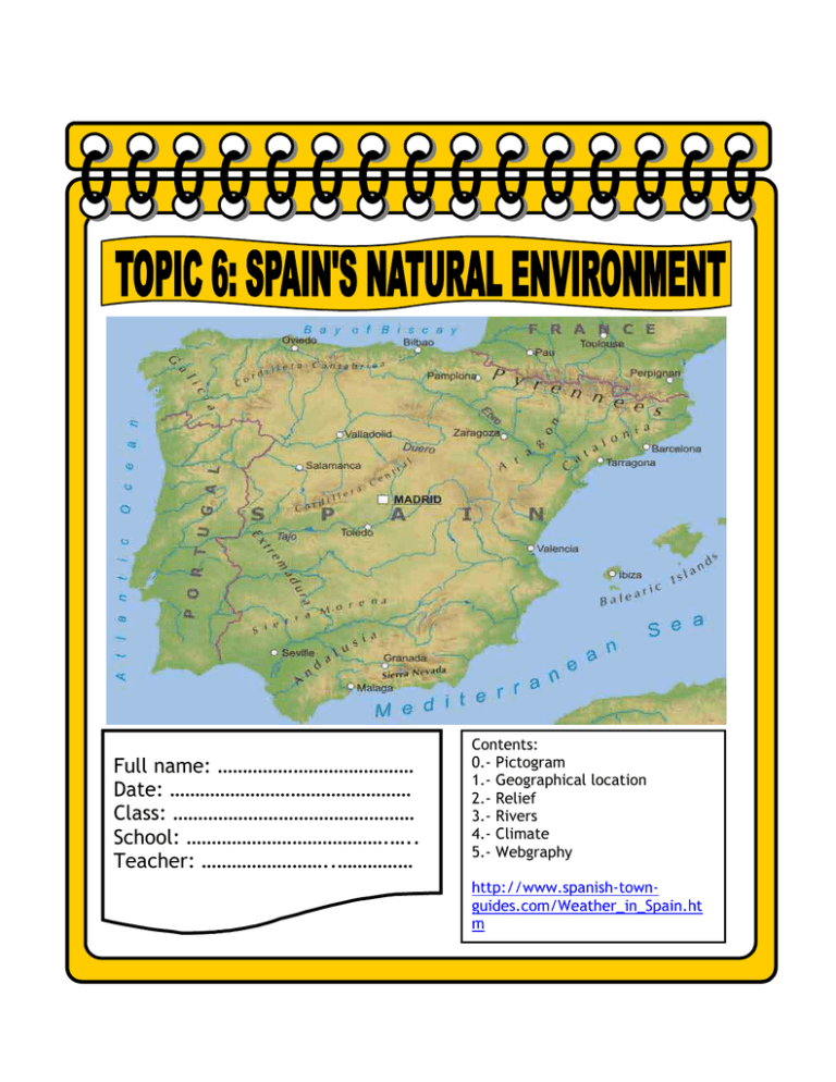
Full name: ………………………………… Date: ………………………………………… Class: ………………………………………… School: ………………………………….….. Teacher: ……………………..…………… Contents: 0.- Pictogram 1.- Geographical location 2.- Relief 3.- Rivers 4.- Climate 5.- Webgraphy http://www.spanish-townguides.com/Weather_in_Spain.ht m A -around: por, alrededor de B - beyond: más allá de C - country: país D - dry: seco E F - find: encontrar - flow into: desembocar G H -hot: caluroso -high: alto - higher than: más alto que -the highest: el más alto I - is found: se encuentra J K L - less: menos - low: bajo - location: situación M - mild: suave -mountain range: cadena montañosa N O - our: nuestro/a/os/as COMPARISON OF SHORT ADJECTIVES P Q R - rainfall: precipitación -river: río S - stream: corriente, flujo - surrounded: rodeado T - tributary: afluente V - valley: valle W - which: el cual, la cual - while: mientras que 1.- Geographical location Spain is found in the Southwest of Europe in the Iberian peninsula. It also occupies the Balearic islands, the Canary islands, Ceuta and Melilla. Our country is surrounded by the Atlantic Ocean and the Mediterranean Sea. 2.- Relief Valleys: Ebro and Guadalquivir valleys are found around and beyond the Meseta. Mountain Ranges: The Pyrenees, the Cordillera Cantábrica, the Macizo Galaico-Leonés, the Sistemas BéticosCordilleras Costero-Catalanas and Sierra Tramontana which is found on the island of Mallorca. Volcano: Teide is the highest point in Spain. It is found in Tenerife. Islands: Mallorca, Menorca, Ibiza, Formentera and Cabrera are found on the Balearic islands while Tenerife, Gran Canaria, Lanzarote, Fuerteventura , La Palma, El Hierro and La Gomera are found on the Canary Islands. Activity two. Give a definition for: Activity one. Give a name to each island. An atlas can help - Mountain. By mountain we understand you an elevation of land higher than a hill. - Island. ………………………………………… …………………………………………………………. ……………………………………………………….. - Valley. ………………………………………… ……………………………………………………….. ……………………………………………………….. 3.- Rivers A river is a continuous stream of fresh water. Most rivers in Spain flow irregularly. Bidasoa, Nervión and Nalón flow into the Cantabrian Sea. Miño, Duero, Tajo, Guadiana, Guadalquivir, Tinto and Odiel flow into the Atlantic Ocean Ebro, Turia, Júcar y Seugura flow into the Mediterranean Sea. 4.- Climate In a very general sense, the south is warm and dry while the north is cooler and more rainy. In the coast, the difference between high and low temperatures is not wide. In the interior the contrast in temperatures is greater. 4.1. Continental climate. It is the most predominant climate in Spain. Winters are cold and summers are hot. Most of the rainfall occurs in late spring. 4.2. Mediterranean climate. Winters are generally mild while summers are hot and dry. Temperatures are moderate. 4.3. Oceanic climate. Oceanic zones have got extensive rainfall. Summers are warm while winters are less cold than in continental zones. 4.4 Mountain climate. These areas have got cold winters and mild summers. Snow and strong winds are also common. 4.5 Arid climate. This area is hot and dry with very little rainfall. Activity three. Write the name of the activity under the appropriate picture and then answer the questions ACTIVITIES IN THE MOUNTAIN ACTIVITIES ON THE BEACH trekking rock-climbing skiing snowboarding mountain-biking 1 snorkelling windsurfing swimming running on the beach 3 2 2 1 4 5 3 4 Activity four. What’s your favourite place, the mountain or the beach?….………………………………..…….. ……………………………………………….Why? My favourite place is ………………………………… because ………………………………………………………………………………………………………….…………………………………. What kind of activities can you do in the mountain and on the beach? The pictures can help you. In the mountain we can ………………………………………………………………………………………………….. while on the beach we ……………………………………………………………………………………………………. …………………………………………………………………………………………………………………………………………. Activity five. Are these statements TRUE or FALSE? Justify the false ones. 1.- You can find Spain in the Northeast of Europe. ……… …………………………………………………………………………………………………………………………………………… 2.- Formentera is found in the Canary Islands. ………. ……………………………………………………………………………………………………………………………………………. 3.- The North of Spain is cool and rainy in a general sense. ……….. ……………………………………………………………………………………………………………………………………………. 4.- The Mediterranean climate has got dry and hot summers. ……….. ……………………………………………………………………………………………………………………………………………. 5.- Snow and rainfalls are common in arid climate. ……….. …………………………………………………………………………………………………………………………………………… Activity six. Complete the diagram Rivers Relief - Valleys. …………………….…………. ………………………………… ………………………….……. - Volcano. ………………………………… - …………………………… . …………………..…………… ………………..……………… …………….…………………. - Cantabrian Sea: Bidasoa, ……………………….. - ……………………………………. : Guadalquivir, …………………. ………………………………………… - Mediterranean Sea : ……………………………………….. ………………………………………… .………………….. - Continental climate. Winters are ………….. Summers are ………… - ……………………………. Winters are …………… Summers are ………… - Oceanic climate Summers are ………… Winters are …………… - ……………………………. Winters …………………. Summers ………………. -Islands. ………….……………………. ………..……………………… ………………………………. Location: - Arid climate ……………………………… …………………………….. Activity seven. Look at the map. Draw these geographical features in the appropriate place 1.- Cantabrian Sea, Mediterranean Sea, Atlantic Ocean. 2.- Bidasoa, Nervión and Nalón, Miño, Duero, Tajo, Guadiana, Guadalquivir, Ebro Júcar and Segura. 3.- Mallorca, Menorca, Ibiza, Formentera, Cabrera, Tenerife, Gran Canaria, Lanzarote, Fuerteventura , La Palma, El Hierro and La Gomera.
