Datos de Aeródromo Cuatro Vientos
Anuncio

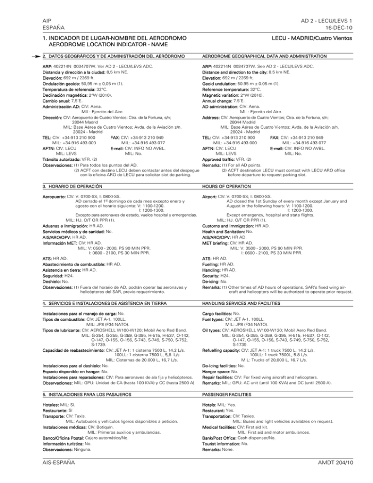
AIP ESPAÑA AD 2 - LECU/LEVS 1 16-DEC-10 1. INDICADOR DE LUGAR-NOMBRE DEL AERODROMO AERODROME LOCATION INDICATOR - NAME LECU - MADRID/Cuatro Vientos 2. DATOS GEOGRÁFICOS Y DE ADMINISTRACIÓN DEL AERÓDROMO AERODROME GEOGRAPHICAL DATA AND ADMINISTRATION ARP: 402214N 0034707W. Ver AD 2 - LECU/LEVS ADC. Distancia y dirección a la ciudad: 8,5 km NE. Elevación: 692 m / 2269 ft. Ondulación geoide: 50,95 m ± 0,05 m (1). Temperatura de referencia: 32°C. Declinación magnética: 2°W (2010). Cambio anual: 7,5’E. Administración AD: CIV: Aena. MIL: Ejercito del Aire. Dirección: CIV: Aeropuerto de Cuatro Vientos; Ctra. de la Fortuna, s/n; 28044 Madrid MIL: Base Aérea de Cuatro Vientos; Avda. de la Aviación s/n. 28024 - Madrid TEL: CIV: +34-913 210 900 FAX: CIV: +34-913 210 949 MIL: +34-916 493 000 MIL: +34-916 493 077 AFTN: CIV: LECU E-mail: CIV: INFO NO AVBL. MIL: LEVS MIL: No. Tránsito autorizado: VFR. (2) Observaciones: (1) Para todos los puntos del AD. (2) ACFT con destino LECU deben contactar antes del despegue con la oficina ARO de LECU para solicitar slot de parking. ARP: 402214N 0034707W. See AD 2 - LECU/LEVS ADC. Distance and direction to the city: 8.5 km NE. Elevation: 692 m / 2269 ft. Geoid undulation: 50.95 m ± 0.05 m (1). Reference temperature: 32°C. Magnetic variation: 2°W (2010). Annual change: 7.5’E. AD administration: CIV: Aena. MIL: Ejercito del Aire. Address: CIV: Aeropuerto de Cuatro Vientos; Ctra. de la Fortuna, s/n; 28044 Madrid MIL: Base Aérea de Cuatro Vientos; Avda. de la Aviación s/n. 28024 - Madrid TEL: CIV: +34-913 210 900 FAX: CIV: +34-913 210 949 MIL: +34-916 493 000 MIL: +34-916 493 077 AFTN: CIV: LECU E-mail: CIV: INFO NO AVBL. MIL: LEVS MIL: No. Approved traffic: VFR. (2) Remarks: (1) For all AD points. (2) ACFT destination LECU must contact with LECU ARO office before departure to request parking slot. 3. HORARIO DE OPERACIÓN HOURS OF OPERATION Aeropuerto: CIV: V: 0700-SS; I: 0800-SS. AD cerrado el 1er domingo de cada mes excepto enero y agosto con el horario siguiente: V: 1100-1200. I: 1200-1300. Excepto para aeronaves de estado, vuelos hospital y emergencias. MIL: HJ. O/T OR PPR (1). Aduanas e Inmigración: HR AD. Servicios médicos y de sanidad: No. AIS/ARO/OPV: HR AD. Información MET: CIV: HR AD. MIL: V: 0500 - 2000, PS 90 MIN PPR. I: 0600 - 2100, PS 30 MIN PPR. ATS: HR AD. Abastecimiento de combustible: HR AD. Asistencia en tierra: HR AD. Seguridad: H24. Deshielo: No. Observaciones: (1) Fuera del horario de AD, podrán operar las aeronaves y helicópteros del SAR, previo requerimiento. Airport: CIV: V: 0700-SS; I: 0800-SS. AD closed the 1st Sunday of every month except January and August in the following hours: V: 1100-1200. I: 1200-1300. Except emergency, hospital and state flights. MIL: HJ. O/T OR PPR (1). Customs and Immigration: HR AD. Health and Sanitation: No. AIS/ARO/OPV: HR AD. MET briefing: CIV: HR AD. MIL: V: 0500 - 2000, PS 90 MIN PPR. I: 0600 - 2100, PS 30 MIN PPR. ATS: HR AD. Fuelling: HR AD. Handling: HR AD. Security: H24. De-icing: No. Remarks: (1) Other times of AD hours of operations, SAR’s fixed wing aircraft and helicopters will be authorized to operate prior request. 4. SERVICIOS E INSTALACIONES DE ASISTENCIA EN TIERRA HANDLING SERVICES AND FACILITIES Instalaciones para el manejo de carga: No. Tipos de combustible: CIV: JET A-1, 100LL. MIL: JP8 (F34 NATO). Tipos de lubricante: CIV: AEROSHELL W100-W120; Mobil Aero Red Band. MIL: G-354, G-355, G-359, G-395, H-515, H-537, O-142, O-147, O-155, O-156, S-743, S-749, S-750, S-752, S-1739. Capacidad de reabastecimiento: CIV: JET A-1: 1 cisterna 7500 L, 14,2 L/s. 100LL: 1 cisterna 7500 L, 5,8 L/s. MIL: Cisternas de 20.000 L, 16,7 L/s. Instalaciones para el deshielo: No. Espacio disponible en hangar: No. Instalaciones para reparaciones: CIV: Para aeronaves de ala fija y helicópteros. Observaciones: MIL: GPU: Unidad de CA (hasta 100 KVA) y CC (hasta 2500 A). Cargo facilities: No. Fuel types: CIV: JET A-1, 100LL. MIL: JP8 (F34 NATO). Oil types: CIV: AEROSHELL W100-W120; Mobil Aero Red Band. MIL: G-354, G-355, G-359, G-395, H-515, H-537, O-142, O-147, O-155, O-156, S-743, S-749, S-750, S-752, S-1739. Refuelling capacity: CIV: JET A-1: 1 truck 7500 L, 14.2 L/s. 100LL: 1 truck 7500L, 5.8 L/s. MIL: Trucks of 20,000 L, 16.7 L/s. De-Icing facilities: No. Hangar space: No. Repair facilities: CIV: For fixed wing aircraft and helicopters. Remarks: MIL: GPU: AC unit (until 100 KVA) and DC (until 2500 A). 5. INSTALACIONES PARA LOS PASAJEROS PASSENGER FACILITIES Hoteles: MIL: Sí. Restaurante: Sí Transporte: CIV: Taxis. MIL: Autobuses y vehículos ligeros disponibles a petición. Instalaciones médicas: CIV: Botiquín. MIL: Primeros auxilios y ambulancias. Banco/Oficina Postal: Cajero automático/No. Información turística: No. Observaciones: Ninguna. Hotels: MIL: Yes. Restaurant: Yes. Transportation: CIV: Taxies. MIL: Buses and light vehicles availables on request. Medical facilities: CIV: First aid kit. MIL: First aid and motor ambulances. Bank/Post Office: Cash dispenser/No. Tourist information: No. Remarks: None. AIS-ESPAÑA AMDT 204/10 AD 2 - LECU/LEVS 2 05-MAY-11 AIP ESPAÑA 6. SERVICIOS DE SALVAMENTO Y EXTINCIÓN DE INCENDIOS RESCUE AND FIRE FIGHTING SERVICE Categoría de incendios: CIV: 3. MIL: 5. Equipo de salvamento: De acuerdo a la categoría de incendios publicada. Retirada de aeronaves inutilizadas: CIV: Hasta 5000 kg. MIL: Tractores remolcadores. Observaciones: Ninguna. Fire category: CIV: 3. MIL: 5. Rescue equipment: In accordance with the fire category published. Removal of disabled aircraft: CIV: Up to 5000 kg. MIL: Pulling tractors. Remarks: None. 7. DISPONIBILIDAD ESTACIONAL/REMOCIÓN DE OBSTÁCULOS SEASONAL AVAILABILITY/OBSTACLE CLEARING Equipo: No. Prioridad: No. Observaciones: Ninguna. Equipment: No. Priority: No. Remarks: None. 8. DETALLES DEL ÁREA DE MOVIMIENTO MOVEMENT AREA DETAILS Plataforma: Superficie: Hormigón y asfalto. Resistencia: PCN 19/F/B/W/U. Calles de rodaje: Anchura: 15 m. (1) Superficie: Asfalto. (1) Resistencia: PCN 19/F/B/W/U excepto E: PCN 25/F/B/W/U. (1) Posiciones de comprobación: Altímetro: Plataforma MIL: P1 692 m / 2270 ft. P2 691 m / 2266 ft. P3 684 m / 2243 ft. Plataforma CIV: INFO NO AVBL. VOR: No. INS: No. Observaciones: (1) Excepto C-1 y J-1 Calles de rodaje aéreo de helicópteros. Apron: Surface: Concrete and asphalt. Strength: PCN 19/F/B/W/U. Taxiways: Width: 15 m. (1) Surface: Asphalt. (1) Strength: PCN 19/F/B/W/U except E: PCN 25/F/B/W/U. (1) Check locations: Altimeter: MIL apron: P1 692 m / 2270 ft.. P2 691 m / 2266 ft. P2 684 m / 2243 ft. CIV apron: INFO NO AVBL. VOR: No. INS: No. Remarks: (1) Except C-1 y J-1 Air taxiways for helicopters. 9. SISTEMAS Y SEÑALES DE GUÍA DE RODAJE TAXIING GUIDANCE SYSTEM AND MARKINGS Sistema de guía de rodaje: Letreros, letreros de NO ENTRY y puntos de espera en pista. Señalización de RWY: Designadores, umbral, eje, faja lateral, punto de visada y zona de toma de contacto. Señalización de TWY: Eje y borde. C-1 y J-1: Eje. Observaciones: Ninguna. Taxiing guidance system: Boards, NO ENTRY boards and runway-holding positions. RWY markings: Designators, threshold, centre line, side stripe, aiming point and touch-down zone. TWY markings: Centre line and edge. C-1 and J-1: Centre line. Remarks: None. 10. OBSTÁCULOS OBSTRUCTIONS En áreas de aproximación y despegue / In approach and take-off areas En el área de circuito y en el AD / In circling area and at AD RWY Area Obstáculo Obstruction Coordenadas Coordinates 698 m / 2289 ft 742 m / 2434 ft Antena/Antenna 872 m / 2861 ft Antena/Antenna 784 m / 2572 ft 402227.4N 0034706.3W 402304.0N 0034713.0W * 402518.0N 0033943.0W * Obstáculo Obstruction Coordenadas Coordinates 402532.0N 0034238.0W * Observaciones: *Coordenadas transformadas. Exactitud desconocida. Ver AD 2 - LECU AOC. Remarks: *Transformed coordinates. Accuracy unknown. See AD 2 - LECU AOC. 11. SERVICIO METEOROLÓGICO PRESTADO METEOROLOGICAL SERVICE PROVIDED Oficina MET: CIV: Madrid/Cuatro Vientos MET. MIL: OMBA de la Base Aérea de Cuatro Vientos. HR: CIV: HR AD. MIL: V: 0500-2000, PS 90 MIN PPR. I: 0600-2100, PS 30 MIN PPR. METAR: Semihorario. TAF: 9 HR. TREND: No. Información: CIV: Teléfono, correo electrónico y AMA. MIL: En persona y resto de medios. Documentación de vuelo/Idioma: Cartas y lenguaje claro / Español. Cartas: Mapas significativos y de viento y temperatura en altitud. Equipo suplementario: CIV: AMA. MIL: Presentador de imágenes de nubes, rayos, y de información radar. Dependencia ATS atendida: TWR. Información adicional: Oficina principal Madrid; H24; TEL: +34-915 045 807. Oficina meteorológica Madrid/Cuatro Vientos; 0500-2100 Hora Z; TEL: +34-916 493 066. Observaciones: Existe resumen climatológico de aeródromo. Se hacen avisos de aeródromo. MET office: CIV: Madrid/Cuatro Vientos MET. MIL: OMBA of Cuatro Vientos Air Base. HR: CIV: HR AD. MIL: V: 0500-2000, PS 90 MIN PPR. I: 0600-2100, PS 30 MIN PPR. METAR: Half-hourly. TAF: 9 HR. TREND: No. Briefing: CIV: Telephone, email and AMA. MIL: In person and all the other means. Flight documentation/Language: Charts and plain language / Spanish. Charts: Significant forecasted and wind and temperaturein altitude maps. Supplementary equipment: CIV: AMA. MIL: Clouds and lightnings image and radar information display. ATS unit served: TWR. Additional information: Main office Madrid; H24; TEL: +34-915 045 807. Meteorological office Madrid/Cuatro Vientos; 0500-2100 H Z; TEL: +34-916 493 066. Remarks: Aerodrome climatological summary available. Aerodrome warnings available. AMDT 209/11 AIS-ESPAÑA AIP ESPAÑA AD 2 - LECU/LEVS 3 05-MAY-11 12. CARACTERÍSTICAS FÍSICAS DE LA PISTA RWY Orientación Direction DIM (m) RUNWAY PHYSICAL CHARACTERISTICS THR PSN THR ELEV TDZ ELEV SWY (m) CWY (m) Franja (m) Strip (m) OFZ RESA (m) RWY/SWY SFC PCN 10 093.78° GEO 1500 x 30 096° MAG 402216.04N THR: 692 m / 2269 ft 0034738.14W TDZ: No 60 x 30 60 x 150 1740 x 80 No No RWY: Asfalto/Asphalt PCN 25/F/B/W/U SWY: Info no avbl 28 273.79° GEO 1500 x 30 276° MAG 402212.84N THR: 686 m / 2250 ft 0034634.87W TDZ: No 60 x 30 60 x 150 1740 x 80 No No RWY: Asfalto/Asphalt PCN 25/F/B/W/U SWY: Info no avbl 10 (1) 094.10° GEO 1127 x 45 096° MAG 402220.43N THR: 690 m / 2264 ft 0034726.54W TDZ: No No No No No No Terreno natural Natural soil 28 (1) 274.10° GEO 1127 x 45 276° MAG 402217.84N THR: 684 m / 2244 ft 0034639.32W TDZ: No No No No No No Terreno natural Natural soil 60 m CWY SWY THR 10 0.50% 880 m 620 m 1500 m 13. DISTANCIAS DECLARADAS RWY 10 28 0.23% 685.72 m 687.12 m Remarks: (1) Closed to civil traffic. Profile: 691.52 m Observaciones: (1) Cerrada al tráfico civil. Perfil: 60 m CWY SWY THR 28 DECLARED DISTANCES TORA (m) TODA (m) ASDA (m) LDA (m) 1500 1500 1560 1560 1560 1560 1500 1500 Observaciones: Ninguna. Remarks: None. 14. ILUMINACIÓN DE APROXIMACIÓN Y DE PISTA APPROACH AND RUNWAY LIGHTING Pista: 10 Aproximación: Sencillo, 420 m. Luces de identificación de umbral. (1) PAPI: 3°. Umbral: Verdes. Zona de toma de contacto: No. Eje pista: No. Borde de pista: 1500 m: 900 m blancas + 600 m amarillas. (1) Distancia entre luces: 50 m. Extremo de pista: Rojas. Zona de parada: No. Observaciones: (1) Luces de intensidad variable. Runway: 10 Approach: Simple, 420 m. Threshold identification lights. (1) PAPI: 3°. Threshold: Green. Touch-down zone: No. Runway centre line: No. Runway edge: 1500 m: 900 m white + 600 m yellow. (1) Distance between lights: 50 m. Runway end: Red. Stopway: No. Remarks: (1) Adjustable lights intensity. Pista: 28 Aproximación: Sencillo, 360 m. Luces de identificación de umbral. (1) PAPI: 2,8°. Umbral: Verdes. Zona de toma de contacto: No. Eje pista: No. Borde de pista: 1500 m: 900 m blancas + 600 m amarillas. (1) Distancia entre luces: 50 m. Extremo de pista: Rojas. Zona de parada: No. Observaciones: (1) Luces de intensidad variable. Runway: 28 Approach: Simple, 360 m. Threshold identification lights. (1) PAPI: 2.8°. Threshold: Green. Touch-down zone: No. Runway centre line: No. Runway edge: 1500 m: 900 m white + 600 m yellow. (1) Distance between lights: 50 m. Runway end: Red. Stopway: No. Remarks: (1) Adjustable lights intensity. 15. OTRA ILUMINACIÓN, FUENTE SECUNDARIA DE ENERGÍA OTHER LIGHTING, SECONDARY POWER SUPPLY ABN: 1 cerca del AD. WDI: 1 cerca THR 10, 1 cerca THR 28. No LGTD. Iluminación de TWY: Borde. C-1 y J-1: Eje. Iluminación de plataforma: 6 torres de 12 proyectores cada una. Fuente secundaria de energía: Grupo electrógeno, arranque 3 s y un tiempo máximo de conmutación de 14 s. Observaciones: Ninguna. ABN: 1 near AD. WDI: 1 near THR 10, 1 near THR 28. Not LGTD. TWY lighting: Edge. C-1 y J-1: Centre line. Apron lighting: 6 towers with 12 floodlighting each one. Secondary power supply: Engine generators, start-up 3 s and a maximum switch-over time of 14 s. Remarks: None. AIS-ESPAÑA AMDT 209/11 AD 2 - LECU/LEVS 4 05-MAY-11 AIP ESPAÑA 16. ZONA DE ATERRIZAJE PARA HELICÓPTEROS HELICOPTER LANDING AREA Situación: Al norte del ARP. Elevación: No. Dimensiones, superficie, carga admisible, señalización: Plataforma nº 1 (principal): 30 m x 40 m, base hormigón - superficie asfalto. Plataforma nº 2 (secundaria): 18 m x 18 m / Terreno natural. TWY: 10 m x 142 m / Asfalto. Orientación: No. Distancias declaradas: No. Iluminación: No. Observaciones: Prohibida su utilización a aeronaves civiles. VASIS en plataforma de helicópteros 28/10. Position: To North of ARP. Elevation: No. Dimensions, surface, maximum weight, marking: Apron nº 1 (main): 30 m x 40 m, base concrete - surface asphalt. Apron nº 2 (secondary): 18 m x 18 m / Natural soil. TWY: 10 m x 142 m / Asphalt. Direction: No. Declared distances: No. Lighting: No. Remarks: Use forbidden to civil aircraft. VASIS at helicopter apron 28/10. 17. ESPACIO AÉREO ATS ATS AIRSPACE Denominación y límites laterales Designation and lateral limits Límites verticales Vertical limits Clase de espacio aéreo Airspace class Unidad responsable Idioma Unit Language Altitud de transición Transition altitude 600 m HGT (2) D Cuatro Vientos TWR ES/EN 3962 m/13000 ft MADRID/CUATRO VIENTOS ATZ Círculo de 3 km de radio centrado en ARP. Circle radius 3 km centred on ARP. (1) Observaciones: (1) O la visibilidad horizontal, lo que resulte inferior. Remarks: (1) Or the ground visibility, whichever is lower. (2) O hasta la elevación del techo de nubes, lo que resulte más bajo. (2) Or up to the clouds height, whichever is lower. 18. INSTALACIONES DE COMUNICACIÓN ATS Servicio Service TWR ATIS ATS COMMUNICATION FACILITIES Distintivo llamada Call sign FREQ (MHz) HR Cuatro Vientos TWR 118.700 121.500 121.800 137.525 139.300 257.800 122.500 118.225 HR AD H24 HR AD H24 H24 H24 HR AD HR AD Cuatro Vientos Information Observaciones Remarks EMERG GMC MIL MIL MIL BACK UP. 19. RADIOAYUDAS PARA LA NAVEGACIÓN Y EL ATERRIZAJE RADIO NAVIGATION & LANDING FACILITIES Instalación (VAR) Facility (VAR) ID FREQ HR Coordenadas Coordinates NDB (2ºW) CVT 285.000 kHz H24 402204.0N 0034624.3W ELEV DME Observaciones Remarks COV 25 NM. U/S en/in sector BTN 169º-189º y en/and in sector BTN 329º-359º. 20. REGLAMENTACIÓN LOCAL LOCAL REGULATIONS AD disponible sólo para aeronaves militares y aeronaves de Estado en VFR y para aeronaves ligeras civiles en VFR. AD available only for military aircraft and State aircraft on VFR and light civil aircraft on VFR. Aeronaves de estela media previa solicitud y posterior autorización ATC local y Dirección de aeropuerto. Con las siguientes limitaciones de velocidad para entradas y salidas por los puntos visuales y maniobras en circuito: Medium wake aircraft prior request and clearance later local ATC and Airport Management. With those speed limits for entries and exits by the visual points and manoeuvring in circuit: Aeronaves civiles ligeras Light civil aircraft Aeronaves civiles estela media Medium wake civil aircraft Tipo de aeronave Aircraft type Todas / All Todas / All IAS MAX 150 kt 150 kt AD utilizable sólo por pasajeros. AD available only for passengers. AD cerrado para aviones sin radiocomunicación en ambos sentidos. AD closed to aircraft without two ways radiocommunication. MÍNIMOS OPERACIONALES OPERATIONAL MINIMA Mínimos operacionales de AD para aeronaves en aterrizajes, despegues y sobrevuelos en condiciones visuales dentro del ATZ: AD operational minima for landing, take-off and overflying the ATZ in visual conditions: A.- Aeronaves civiles: • Techo de nubes para aviones: 300 m. para helicópteros: 200 m. • Visibilidad horizontal para aviones: 2,5 km. para helicópteros: 1,5 km. A.- Civil aircraft: • Cloud height for fixed wing aircraft: 300 m. for helicopters: 200 m. • Horizontal visibility for fixed wing aircraft: 2.5 km. for helicopters: 1.5 km. AMDT 209/11 AIS-ESPAÑA AIP ESPAÑA AD 2 - LECU/LEVS 5 WEF 17-NOV-11 B.- Aeronaves militares: • Techo de nubes: - Para aviones: Despegues, 183 m. Aterrizajes, 206 m. - Para helicópteros: Despegues, 91 m. Aterrizajes, 91 m. • Visibilidad horizontal: - Para aviones: Despegues, 2 km. Aterrizajes, 2,5 km. - Para helicópteros: Despegues, 1 km. Aterrizajes, 1 km. B.- Military aircraft: • Clouds height: - For fixed wing aircraft: Take-off, 183 m. Landing, 206 m. - For helicopters: Take-off, 91 m. Landing, 91 m. • Horizontal visibility: - For fixed wing aircraft: Take-off, 2 km. Landing, 2.5 km. - For helicopters: Take-off, 1 km. Landing, 1 km. Aeronaves en misión SAR, Emergencia o Estado, a criterio del comandante de la aeronave. Aircraft in SAR, Emergency or State mission, upon the criteria of the pilot in command. PLATAFORMAS MILITARES MILITARY APRONS Debido a las características de las líneas de guía de rodaje a los estacionamientos de las plataformas militares, las operaciones de aeronaves con envergadura mayor a 20 metros o de aeronaves con longitud mayor a 16 metros deben ser ejecutadas, en esta área, con extrema precaución. Las aeronaves deberán esperar en la entrada de la plataforma de estacionamiento militar asignada por TWR la llegada del vehículo "SÍGAME" o señalero para ser guiado al lugar designado para su aparcamiento. Due to the characteristics of the taxiing guidance system to the parking positions in the military aprons, operations in this area of aircraft with wing span greater than 20 metres or length greater than 16 metres, must be executed taking extreme caution. Aircraft will wait at the entry of the military apron designated by TWR for the arrival of a "FOLLOW ME" vehicle or signalman in order to be guided to the stand position designated for its parking. 21. PROCEDIMIENTOS DE ATENUACIÓN DE RUIDOS NOISE ABATEMENT PROCEDURES No. No. 22. PROCEDIMIENTOS DE VUELO FLIGHT PROCEDURES Las aeronaves que despeguen por la RWY 10 abandonarán el circuíto de tránsito del AD después de finalizar el tramo de viento en cola derecho y pedirán permiso a la torre cuando vayan a cruzar la zona de aproximación a la RWY 10. Aircraft taking-off from RWY 10 shall leave the aerodrome traffic circuit after finishing the right tale wind leg and ask for clearance to control tower to cross the approach area of RWY 10. PROCEDIMIENTOS DE VISIBILIDAD REDUCIDA (LVP) LOW VISIBILITY PROCEDURES (LVP) El aeropuerto de Madrid/Cuatro Vientos no dispone de Procedimientos de Visibilidad Reducida (LVP) Low Visibility Procedures (LVP) are not available at Madrid/Cuatro Vientos airport. CIRCUITO DE TRÁNSITO DE AD. AD TRAFFIC CIRCUIT. HGT MAX 656 ft HEL HGT MAX 328 ft HGT MAX 328 ft APCH ACFT con fallo de comunicaciones APCH ACFT with communications failure CIRCUITO DE TRÁNSITO TRAFFIC CIRCUIT / HGT 656 ft Circuito de helicópteros del hospital militar Gómez-Ulla. Helicopters circuit of Gómez-Ulla military hospital. LLEGADAS: Los helicópteros con destino al helipuerto establecerán contacto radio con TWR de Madrid/Cuatro Vientos 5 minutos antes de su hora estiamda de llegada, notificando posición e intenciones, al objeto de recibir información del tránsito esencial. ARRIVALS: Helicopters destination this heliport must establish contact radio with Madrid/Cuatro Vientos TWR 5 minutes before the estimated time of arrival, notifying position and intentions, with the object of receive information of main traffic. SALIDAS: Los helicópteros que se dispongan a salir de este helipuerto establecerán contacto radio con TWR de Madrid/Cuatro Vientos antes de despegar, notificando la ruta a seguir después del despegue, para recibir instrucciones. DEPARTURES: Helicopters prepare to take-off from this heliport must establish contact radio with Madrid/Cuatro Vientos TWR before taking-off, notifying the route to be follow after take-off, in order to receive instructions. AIS-ESPAÑA AIRAC AMDT 10/11 AD 2 - LECU/LEVS 6 WEF 17-NOV-11 AIP ESPAÑA 23. INFORMACIÓN SUPLEMENTARIA ADDITIONAL INFORMATION Precaución debido a agua estancada en RWY y TWY bajo condiciones de lluvia de intensidad moderada. Caution due to standing water on RWY and TWY under moderate rain conditions. AIRAC AMDT 10/11 AIS-ESPAÑA


