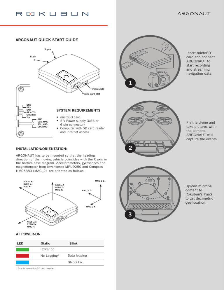
ARGONAUT QUICK START GUIDE 4 pin Insert microSD card and connect ARGONAUT to start recording and streaming navigation data. 6 pin 1 microUSB uSD Card slot GND PPS CAM GPS (TX) CFG (RX) VIN SYSTEM REQUIREMENTS GND SDA_MAG SCL_MAG GPS+IMU • microSD card • 5 V Power supply (USB or 6 pin connector) • Computer with SD card reader and internet access Fly the drone and take pictures with the camera, ARGONAUT will capture the events. 2 INSTALLATION/ORIENTATION: ARGONAUT has to be mounted so that the heading direction of the moving vehicle coincides with the X axis in the bottom case diagram. Accelerometers, gyroscopes and magnetometer from Invensense MPU9250 and Compass HMC5883 (MAG_2) are oriented as follows: MAG_2 Z+ ACCEL Y+ GYRO Y+ MAG X+ ACCEL ZGYRO ZMAG Z+ Upload microSD content to Rokubun’s PaaS to get decimetric geo-location. MAG_2 Y- MAG_2 X- 3 ACCEL X+ GYRO X+ MAG Y+ AT POWER-ON LED Static Blink Power on No Logging* Data logging GNSS Fix * Error in case microSD card inserted CONFIGURATIONS DATA PROCESSING WITH PAAS Can be reconfigured via u-center (uBlox proprietary interfacing SW). Parameters such as data rate, constellations to be tracked or acquisition dynamics can be set within this tool. Rokubun does not recommend to modify the default configuration (especially set for dynamic acquisitions), but in case of need and in trouble with the u-center interface, you can contact us in [email protected] PaaS (paas.rokubun.cat) is used to upload the logged file in the microSD card and get back the improved track up to accuracies better than 40 cm. Use it as well to convert ARGONAUT log file to standard RINEX and CSV (IMU) files. The output of the PaaS is a refined track text file as well as a complete report on the quality of the obtained geo-location estimation. APPLICATIONS - On-board GNSS for navigation Photogrammetric drone campaigns Surveying drone campaigns Research Prototyping SPECIFICATIONS • Real time geo-location accuracy better than 2m. • Offline geo-location accuracy better than 40cm using Rokubun’s PaaS • Multi-constellation: GPS, Galileo, GLONASS, Beidou, SBAS - GPS + GLONASS antenna with increased ground plane for multipath mitigation • Shielded high gain RF subsystem for SNR optimization. • Sensors: - L1 GNSS receiver (u-blox NEO-M8T) - 9 degree IMU (Invensense MPU9250: accelerometer, gyroscope, magnetometer) - Compass HMC5883L (4 pin connector) • Data rates: - GNSS measurements (pseudo-range, carrier-phase, Doppler, C/N0): 10 Hz (default 5 Hz) - IMU measurements: 100 Hz - Real time navigation rate: 5Hz - Offline navigation rate: 100Hz • Compatible with drone controllers (e.g Pixhawk) and remote sensing payloads (e.g Micasense). • GNSS + IMU raw data logger (either via an SD card or using the 6 pin connector) • Receiver can be configured using the USB port, using u-blox u-center software. • The device can be powered via the USB or the 6 pin connector • Connections: - 6 pin connector: JST-GH 1.25 6 pin connector - 4 pin connector: JST-GH 1.25 4 pin connector - Micro USB connector - SD card slot • Dimensions: 65 x 65 x 20 mm • Weight: 60 gr • Power consumption: 80 mA PaaS is also able to enhance the geo-location information in the images meta-data, in case ARGONAUT has been used to register camera events, the images taken to be used in the PaaS processing.
